Complementary Percision Agriculture services by July. 31, 2025!
AI-Powered Drone Inspection
Fewer shutdowns start with smarter scans. SkyFlow turns risky climbs and guesswork into precise, geotagged insight—RGB + thermal imagery, orthomosaic maps, and engineer-ready defect callouts—delivered fast and safely. From roofs and façades to roads, bridges, and PV arrays, we help you spot problems early, prioritize fixes, and keep operations moving—no rope access, no lane closures, no blind spots.
Our team also performs conventional 2D, 3D, and orthomosaic surveys. Using RTK poles for ground control points, we achieve horizontal accuracy of ±2–3 cm and vertical accuracy of ±3–5 cm.
With compliance for ASPRS, ISO 19157, CSA S250 where relevant.
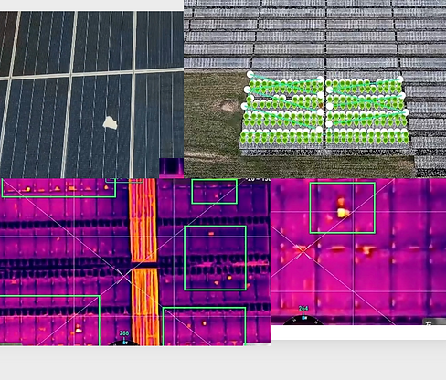
Solar Photovoltaics Inspection
What we check:
-
Electrical anomalies: module/cell hotspots, string mismatch, bypass diode faults, PID/banding.
-
Mechanical/optical: cracked glass, delamination, backsheet damage, snail trails, discoloration.
-
Connections & BOS: hot junction boxes, MC4/connectors, cabling, combiner areas.
-
Layout & shading: row misalignment, tracker/cant issues, snow/soiling coverage assessment, vegetation encroachment.

Industrial Building Inspection,
Ice Prevention & Snow Removal
Hard-to-reach large rooftops need de-icing and snow removal? No problem, we fly on top to get you covered.
Spread snow/ice removal agents with drones!
Infrastructure Integrity Scan
Detect cracks, rust, and insulation damage on roads or buildings using our advanced AI algorithms and comprehensive reporting, which includes a 3D report.


Winter Surface
& Site Surveys
Typical use cases:
- snow-coverage mapping for parking lots/campuses
- salt/sand stockpile volumetrics
- post-storm documentation
- sidewalk/ADA route checks
- drainage/ponding risk mapping
- solar-farm snow coverage, tree/line encroachment along roads.